John Muir Trail Adventure Journal: Day 10
Deer Meadow to Woods Creek Canyon
Approximately 21.6 miles. Cumulative: 162.4 miles.
Of the three groups camped in the Deer Meadow, I was the first one to greet the day. I broke camp, had a quick cup of coffee, and started walking. There had been rumors of a bear in the area, but our three campsites were undisturbed.
At one point, the mosquitoes started getting a little annoying, so I went to put on my mosquito head net … and it wasn’t there. I’d been keeping it in my hip belt pocket. I was bummed. It was a good piece of equipment; lightweight and it did the job it was designed to do very well. Instead, I used my trusty Original Buff (another fabulous piece of gear). It didn’t work quite as well for keeping the bugs from annoying me, but at least it kept them out of my nose and mouth.
As I hiked along toward the Golden Staircase (there were a few minor blowdowns here to negotiate), one of the guys from the fire last night zipped past me. After we greeted each other, I asked him if he happened to see a mosquito net. He had, but he through it belonged to the two ladies who’d camped near us. When they said it wasn’t theirs, he left it on the trail in case someone went back for it.
I can’t remember this guy’s name, but he was one hell of a strong hiker. He could climb steep elevation gains quickly and steadily. He was 23 years younger than me, and I felt every one of those years as I watched him speed up the slopes of the Golden Staircase ahead of me.
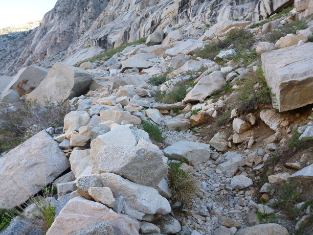
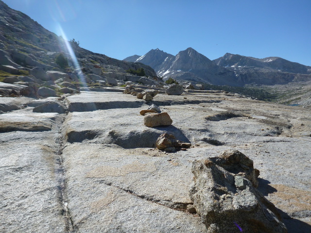
Ah yes, the Golden Staircase. This was the last section of the John Muir Trail to be finished, and it wasn’t complete until 1938, some 23 years after construction of the trail had officially begun.
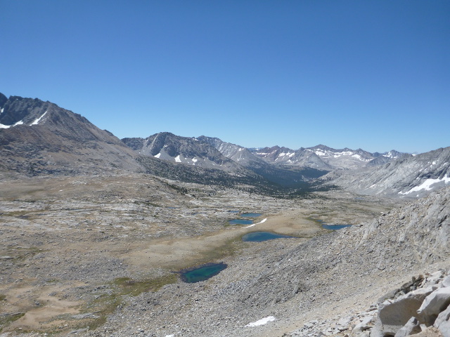
I don’t know why it’s called the Golden Staircase. It’s not golden, and it’s not really a staircase. Instead, it’s a arduous stretch of rocky trail that switchbacks its way up to the Palisade Lakes. It runs parallel to the Palisade Creek, which tumbles down out of the lakes above, so there were plenty of places where waterfalls roared by. I’d pause every so often to rest, catch my breath, and look back into the valley where I’d spent the night.

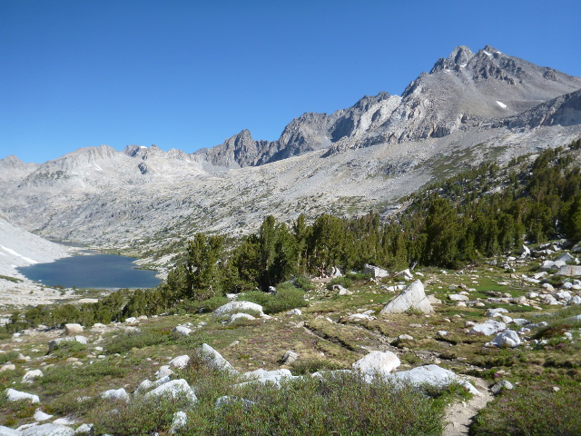
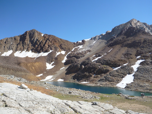
This climb was more difficult than I’d anticipated, and it took a lot out of me. The renewed energy I’d gotten from my stay at VVR was waning. It took me longer than I’d wanted to reach the Palisade Lakes, but when I did, I had to agree with the hiker I’d spoken to the day before that they were indeed beautiful. The Evolution Basin still holds the distinction of being my favorite place along this trail, but Palisade Lakes is a close second.
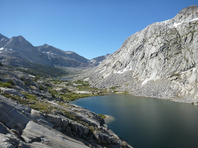
A lot of people had spent the night here. There were at least three distinct groups having breakfast and breaking camp when I hiked by. We all chatted briefly about how great it was to be alive and be in the High Sierras. As I walked along the trail that paralleled the shore of Lower Palisade Lake, I ran into a hiker coming down from Mather Pass. He’d slept up there the night before and pointed it out to me. It looked further away than I wanted it to be.
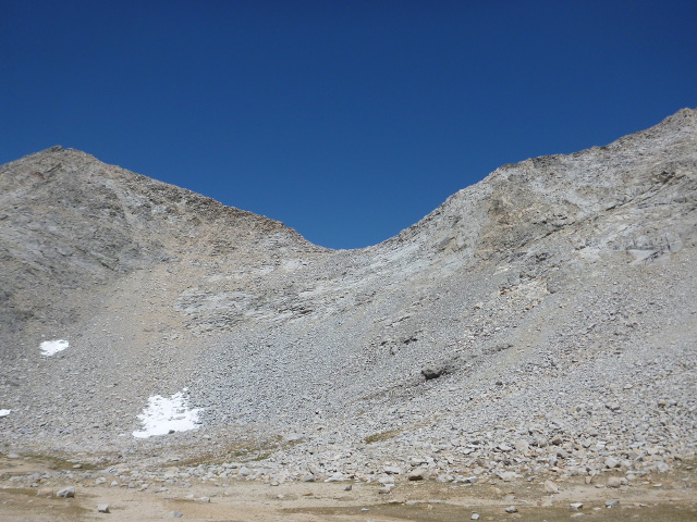
After I passed Upper Palisade Lake, the trail started to climb steadily, leaving almost all vegetation behind, and soon I was on a trail that was all rock.
I slogged up the switchbacks to Mather Pass. This was an intense climb, and pretty tiring. Quite often I sat and rested for a few moments among the huge boulders that made up the talus surrounding the trail. I’d snack often (glad I had those peanut M&Ms) and look around. There were many tiny, nameless alpine lakes peppering the slopes of the surrounding peaks. They were very inviting. Also, the views behind me back at the Palisade Lakes — and the namesake Palisades range of peaks rising up behind them — were spectacular.
During this stretch, the second guy from the campsite the night before cruised by me. He was a young guy, too, just out of college. I don’t feel old that often, but, well, I was feeling pretty old that day. Turns out the three of us would leapfrog each other regularly for the next three days. I caught up to them as they relaxed at the top of Mather Pass.
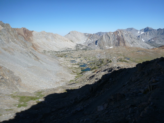
I took a short break there, looked back …
… and looked ahead …
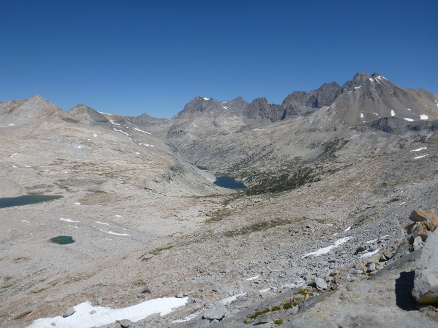
… then kept going. Coming down the other side of Mather Pass was not easy, either. The trail switch-backed all the way down, and footing was treacherous in places. A few times I could hear rocks tumbling down from above. Just a little freaky.
Upon reaching the trail traveled along dry and desert-like terrain for a few miles. I was close to running out of water, the closest I’d been all trip, and it took me a little while to find a likely spot. I was glad for the break and rested near the stream for a few minutes.
It was only 10 miles from Mather Pass to Pinchot Pass, and the day was still early. I was confident I could make it. But for some reason my mood had gotten bad. So I got into a fight with my water bottle.
I was using one of those Platypus Platy Bottles. Great for dayhikes and everyday urban use, but it just doesn’t hold up to long-term abuse on the trail. It worked well for awhile, but by now, I hated it. The damn thing kept falling out of its pocket.
And let me tell you. There’s nothing sillier than a man yelling at his water bottle.
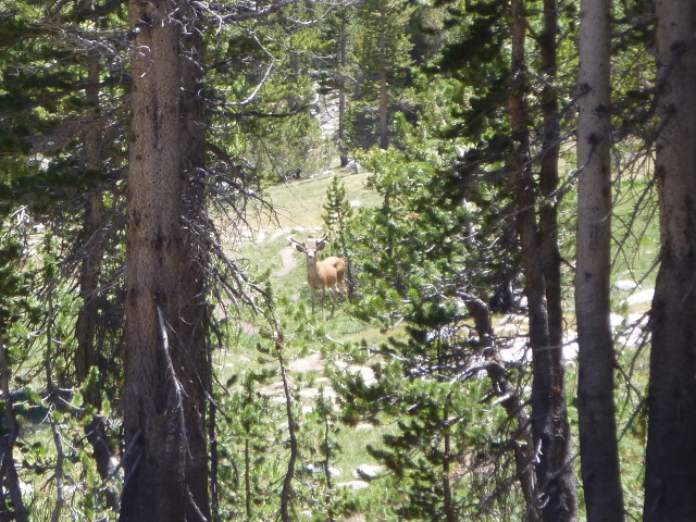
After this long, dry section, the trail entered a lightly forested section. It was nice to get some shade. I wasn’t the only one to think so; this is where I saw my first and only buck mule deer.
Soon enough, I came to the South Fork of the King’s River. I forded my way across it — well, more like jumped across it on a series of partially submerged rocks — ate a snack, then started to climb to Pinchot Pass, eventually passing the Bench Lake Ranger station. The trail kept a slight uphill grade through a pleasant meadow, eventually surrendering to more rugged terrain as I got closer to Pinchot Pass.
I came across another hiker making camp near the Lake Marjorie outlet, right where the trail climbed up to the pass. I was really tired, so I thought about stopping, but it was only 3 P.M. I had a good four hours of hiking and about six miles to go to Sawmill Lake Junction, most of that downhill. I knew I could make the pass, after that, well, I was sure I’d find some place to sleep.
Again, the climbs were getting harder. I rested a lot on the way up. It was, after all, my second pass that day, with a total of more than 5,300 feet of climbing.
Right before the pass, I ran into a guy who asked me if I’d passed a girl. He described her and I remembered passing her on day eight. He asked me a lot of questions about her, but they were weird questions, more stalker than friend. Normally hikers asking about other hikers I’d seen seemed friendly, but this time it seemed a little creepy (this opinion was later corroborated by another hiker, so it wasn’t just me). I answered vaguely. He also told me you couldn’t do 20 miles a day in the Sierras. I didn’t argue, but he was wrong.
I cleared Pinchot Pass and shuffled down, hoping to make Sawmill Pass Trail or something really close. I had a specific campsite in mind, but when I got there, it was taken. I had a brief conversation with the guy camped there about typical hiker stuff. The sun was getting low and I wasn’t sure how far I had to to the next suitable camp. I was tired and wanted to stop there, but something about his body language had me thinking he didn’t want to share the campsite.
So I backtracked a bit to fill up on water at the nearby stream, then walked back by him to wish him well. That’s when he told me he was hiking with another hiker who was in the tent, suffering from a virus. So that made me glad I took the time to treat all the water I drank. You just never know.
That said, I did wonder about the integrity of the batch of water I’d just treated. It was the only time I wondered about the quality of the water source I’d chosen the entire trip. But I sourced it upstream from the camp in the opposite direction they were traveling, so I told myself I’d be all right.
The light was starting to fading; this was the longest I’d gone before making camp, and I had no camp in sight. Fortunately, I met two guys coming up the trail, and they told me about a great campsite about half a mile ahead. And it was below 10,000 feet with a fire ring. That meant I could start a fire.
I hustled and got to the spot as soon as I could. I made camp and started collecting twigs and other small combustibles scattered around the campsite to start a fire. I was being brutalized by mosquitoes as I did this. As great as the Buff was, I sorely missed not having the mosquito net I’d lost that morning.
And I really had to go to the bathroom again (I know, right! I’d just gone the day before!), so I retreated away from camp and did my business while trying my best (mostly failing) to avoid an army of mosquitoes.
I got back to camp and totally abandoned the idea of a fire. I didn’t think it would keep enough of the bugs away, and I was tired and hungry. I jsut wanted to eat and go to bed. I wouldn’t even have time to enjoy a nice campfire.
I cooked dinner in the security of my tent’s vestibule, ate it, cleaned up quickly, and got to bed. The sun had dropped below the peaks and it was well past my bed time.
I nodded off right away. This had been my hardest day yet. I didn’t know it yet, of course, but tomorrow would be worse.
After a cliffhanger like that, I really hope you’re not planning to take a day off writing. 😉 This is great, can’t wait for tomorrow.
I’m very glad you’re enjoying it. No, I’m not taking a day off. The loose first draft of day 11 is done. Now I have to fill in the details, but it will be up this evening.